Ready to embark on a mind-bending journey that will literally change how you see the world? Welcome to the ultimate trivia treasure trove that’s as entertaining as it is enlightening! Trust us, geography isn’t just about memorizing countries and capitals. It’s an enthralling exploration that melds the human experience with the natural wonders of our planet. And guess what? You’re about to become the life of the party and the go-to guru for all things Earth!
Here, we’ve assembled a jaw-dropping collection of geographical tidbits that span the globe, diving deep into both the mesmerizing marvels of physical geography and the intricate tapestry of human geography. From the snowfall in the Sahara Desert to a football stadium on the equator, this list is your passport to understanding the complex and awe-inspiring world we inhabit. We’re talking about oceans, continents, cities, cultures, and phenomena that defy belief—Asia, Europe, Africa, North America, South America, Antarctica, and Oceania are just the beginning!
Mexico’s Hidden Pyramid Wonder
While Egypt often hogs the limelight for its pyramids, Mexico boasts the largest pyramid in terms of volume. Known as Cholula or Tlachihualtepetl, this magnificent structure is cloaked in a blanket of green grass, making it easily mistaken for a natural hill.

An archaeological marvel, the pyramid represents a rich blend of pre-Hispanic cultures. It holds untold secrets still waiting to be uncovered.
The Unique Geographical Position of Africa
Africa is remarkable for many reasons, including its incredible geographical position. You won’t find another continent that lays claim to all four hemispheres: northern, southern, eastern, and western.

This unique location means that Africa is the only landmass intersected by both the Equator and the Prime Meridian. This results in an incredibly diverse range of climates, ecosystems, and cultures, making Africa one of the most multifaceted and fascinating continents globally.
The Enigma of Countries Within Countries
There’s something mysteriously intriguing about countries that are entirely engulfed by other nations. Only three countries can boast this unique feature: San Marino, Vatican City, and Lesotho. Lesotho is an enclave within South Africa, while San Marino and Vatican City are enveloped by Italy.

Due to their unusual geographic conditions, these landlocked countries often possess unique histories, economies, and diplomatic relations, making them captivating subjects for geography enthusiasts.
Alaska’s Dual Geographic Extremes
Alaska is a geographical marvel in many ways. Still, one of its most astonishing features is its simultaneous position as both the easternmost and westernmost state in the USA.

Yes, you read that correctly! While Alaska is undoubtedly the northernmost and westernmost state, its Aleutian Islands stretch so far that they actually extend into the Eastern Hemisphere. At locations like Pochnoi Point, longitude lines converge, placing Alaska in a geographical category of its own.
The Melodic Longevity of Greece’s National Anthem
The Greek National Anthem, composed by Dionysios Solomos in 1823, stands out as an exceptional composition for its sheer length, boasting an astonishing 158 verses.

While national anthems serve as essential symbols of unity and patriotism for countries worldwide, it’s rare to find a Greek who knows this anthem by heart due to its extensive lyrics. Yet, the very length and complexity of the anthem contribute to its enigmatic charm, serving as a poetic narrative of Greek history and culture.
Saudi Arabia’s Resourcefulness in Water Scarcity
You might find it hard to believe, but Saudi Arabia is virtually devoid of natural bodies of water like lakes and rivers. Despite its arid conditions and lack of rainfall, the country has ingeniously adapted through the use of desalination plants and oases.

Additionally, national efforts have transformed certain desert areas, creating patches of intense greenery—achievements that are a testament to human ingenuity in the face of natural limitations.
The One-Letter Wonder: Å
What’s in a name? When it comes to the village of “Å,” quite a lot. Holding the record for the shortest place name in the world, you can find villages with this unique moniker in both Sweden and Norway.

In Scandinavian languages, “Å” translates to “river,” offering a succinct yet meaningful name. One such village resides in the Nordland County of Norway, situated on the picturesque Andoya East Coast Island, making it more than just a geographical oddity but also a stunning travel destination.
The Westward Quirk of Los Angeles and Reno
Believe it or not, Reno, Nevada, is west of Los Angeles, California. At first glance, you may dismiss this fact as improbable, but the geographical coordinates don’t lie.

Even though Reno is nearly 300 miles from the ocean, it is situated about 86 miles farther west than the bustling coastal city of Los Angeles. This counterintuitive geographical fact adds an unexpected layer of intrigue to how we understand the layout of the American West.
The Minuscule Majesty of Vatican City
Vatican City may be the spiritual center for millions of people worldwide, but did you know it’s the smallest independent state on Earth, covering just 5 square kilometers or about 2 square miles?

In stark contrast, the largest urban area is Hulunbuir in Inner Mongolia, China, stretching over 263,953 square kilometers or 101,912 square miles. This juxtaposition between the incredibly small and the incomprehensibly large emphasizes the rich diversity in geographical extremities across the globe.
Maine’s Unlikely Southern Position
Estcourt Station in Maine holds the title of New England’s northernmost community. It tops the list of high municipalities near the Great Lakes. While one might link Maine with chilling winters and northern locales, a surprising fact is that Estcourt Station is actually located farther south than several major European cities.

London is north of this small Maine community by almost 300 miles. Similarly, cities like Paris, Brussels, and Amsterdam are actually situated to the south, challenging our perceptions of geographical latitude.
Australia’s Deceptive Coastline
Australia is a unique case in geography; it’s both a country and a continent entirely surrounded by water. Given its isolation, you’d expect Australia to have the world’s longest coastline.

However, that’s not the case. Despite being enveloped by the ocean, its coastline isn’t the longest on Earth. This intriguing discrepancy adds another layer to Australia’s fascinating geographical profile, defying assumptions about size and scale.
Florida’s Labyrinthine Suburbs
In a quirky twist of suburban planning, a pair of houses in Florida presents a unique geographical trivia. While adjacent with just a fence between their backyards, these homes are separated by a labyrinth of roads that turns a potential walk into a car journey. To travel from one driveway to the other, residents must navigate sprawling suburbia, taking a circuitous path that spans more than 7 miles and eats up 20 minutes of drive time.

This bewildering fact highlights the complexities of urban design where the convenience of road access is sacrificed for the layouts of residential communities. It stands as a curious example of how modern development can create pockets of isolation amidst a sea of houses, making neighbors simultaneously close yet paradoxically distant.
The Staggering Coastline of Canada
Canada’s coastline stretches for an astounding 152,100 miles, dwarfing Australia’s 16,000 miles. What’s more striking is that Australia ranks seventh worldwide, falling behind countries like Japan, the Philippines, Russia, Greenland, and Indonesia.

This discrepancy between the two nations, rich in natural beauty, highlights the vastness of Canada’s coastal territory, providing ample opportunity for exploration and adventure.
The Mind-Bending Illusion of Mercator Maps
While you might think you’ve got a good grasp on the size of the world’s landmasses, the Mercator projection used in many maps might be playing tricks on your perception. Take Greenland, for instance—on a Mercator map, it appears almost as large as Africa. In reality, Africa is a staggering 14 times larger than Greenland!

The Mercator map distorts sizes as you move away from the equator, amplifying the dimensions of countries located closer to the poles. So the next time you’re dazzled by the scale of certain countries or continents, remember that traditional mapping might be toying with your geographic sensibilities!
Divisions of England
England, a country with a rich history and diverse culture, can be divided in numerous ways. This whimsical map offers six light-hearted divisions. From the longstanding Brexit debate labeled as “Brexit” and “Bremain” to the regional food preferences like “Gravy on chips” and “Salt & vinegar on chips.”

The map even touches on historical figures and pirate-infested areas. Whether it’s the preferred dining spot of “Greggs” versus “Pret A Manger” or the beverage choice between “Lager” and “Cider,” this map provides a fun perspective on the different quirks that make up England.
Leap Year’s Extra Day Explained
While commonly cited that a year consists of 365 days, Earth’s actual journey around the Sun takes approximately 365 days, 5 hours, 59 minutes, and 16 seconds. This extra time accumulates, and to recalibrate our calendar with Earth’s orbit, we add an extra day every four years, resulting in a leap year with 366 days. This fascinating astronomical adjustment ensures that our seasons remain consistent over time, anchoring our calendar to the celestial dance of our planet.

To correct this, we introduce a leap day, February 29, every four years. This leap-year phenomenon ensures that our Gregorian calendar remains in harmony with Earth’s slightly elongated orbit. Without this quadrennial correction, we would drift away from the astronomical realities, misaligning our seasons and wreaking havoc on our timekeeping.
Understanding El Niño
El Niño is a powerful climate phenomenon that alters weather patterns across the globe. During a normal year, equatorial winds in the Pacific Ocean drive warm water westward, allowing cold water to rise near South America. However, during an El Niño year, these winds weaken, causing warm water to shift eastward towards South America.
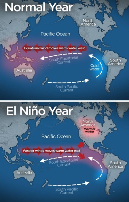
This change disrupts the South Equatorial Current and can lead to warmer winters in North America and severe weather disruptions elsewhere. By influencing global climatic events, El Niño showcases the interconnected nature of our planet’s climate systems and their far-reaching impacts.
France’s Longest Border Is Actually with Brazil
France shares its longest border not with any of its European neighbors but with Brazil in South America. This might seem puzzling at first, but the explanation lies in the overseas region of French Guiana. Located on the northeastern coast of South America, French Guiana is an integral part of France.

The border between French Guiana and Brazil stretches over 730 kilometers (about 453 miles), making it France’s longest border with another country. This geographical fact highlights the unique nature of France’s territories and its global presence, extending far beyond the European continent.
The World’s Largest Desert is Antarctica
Antarctica is often associated with ice rather than sand, but it holds the title of the world’s largest desert. The definition of a desert is not just about sand and heat; it’s about low precipitation. Antarctica fits this description perfectly, receiving less than two inches of precipitation per year, making it an incredibly dry place.

Covering an area of 14 million square kilometers (about 5.4 million square miles), it surpasses the Sahara, traditionally recognized as the largest desert, in size. This fact about Antarctica challenges our typical desert imagery, showcasing the continent’s extreme and arid environment.
Island vs. Continent: The Geological Puzzle of Greenland and Australia
It’s time to unravel a geographical conundrum that often stumps even the most avid trivia fans: Why is Greenland considered the world’s largest island, while Australia, surrounded by water, is deemed a continent? The answer lies beneath the Earth’s surface, in the realm of plate tectonics. Despite both landmasses fitting the basic definition of an island — being completely surrounded by water — their tectonic identities set them apart.

Greenland sits atop the North American tectonic plate, sharing its geological roots with a larger continent, thereby classifying it as an island. On the other hand, Australia boasts its own tectonic plate, distinguishing it as a continent both geologically and by convention. This subtle yet significant difference is a perfect example of how our planet’s dynamic nature can defy simple categorization, making Earth’s geography a continuously fascinating subject.
Arctic Circle’s Unique Cross in Iceland
The Arctic Circle, an imaginary line located roughly at latitude 66.5° north, is unique in its interaction with Iceland. Contrary to what many believe, the majority of Iceland lies just south of this line. However, there’s an exception!

A small island named Grímsey, situated off Iceland’s northern coast, is the only part of the country that the Arctic Circle crosses. For travelers, this little island offers a rare opportunity to step across the boundary separating the Arctic from the rest of the world.
California and Hawaii: A One-Sided Proximity
It’s an intriguing geographical quirk: California is the closest U.S. state to Hawaii, but Hawaii is the furthest state from California. While it takes a flight of about 5 hours to travel the 2,400 miles from California to the Hawaiian Islands, the closest continental U.S. state to Hawaii, the paradisiacal islands in the Pacific have no other state neighbors.

Meanwhile, California shares its borders with Oregon, Nevada, and Arizona. The state’s closest neighbors make it so that Hawaii ends up being its most distant state companion. This geographical fact underscores the isolation of Hawaii, while also highlighting the difference in relationships between states.
Eastward Detroit, Westward Atlanta
When you think of U.S. geography, it’s easy to assume that Detroit is west of Atlanta based on their locations in the Midwest and the South, respectively. However, a closer look at longitude coordinates reveals that Detroit is actually farther east than Atlanta.

Detroit sits at approximately 83.05 degrees west longitude, while Atlanta is at 84.39 degrees west. This geographical twist often baffles people, and it serves as a reminder that intuitive geographical guesses can sometimes lead us astray. It’s these unique quirks that make geography such an intriguing subject.
A Surprising Distance: New Zealand to Australia vs. Netherlands to Libya
The Tasman Sea separating Australia and New Zealand might seem vast, but would you believe it’s roughly the same distance as between the Netherlands and Libya in North Africa? The distance between Sydney and Wellington is around 1,380 miles, closely resembling the 1,400 miles that separate Amsterdam and Tripoli.

While culturally and geographically distinct, this surprising fact reveals that distances can be quite deceptive. It also reminds us how geography often shapes not only physical landscapes but also cultural, economic, and political relations.
Ireland’s Tropical Flair: Palm Trees
Ireland, known for its green landscapes and temperate climate, has an unexpected tropical twist: palm trees grow at 53 degrees north latitude. Thanks to the warm currents of the North Atlantic Drift, part of the Gulf Stream, Ireland enjoys a milder climate than other regions at the same latitude.

This allows certain species of palm trees to grow, adding an unexpected element to the Emerald Isle’s scenery. While they aren’t the same species you’d find in the Caribbean, these palm trees stand as testimony to the incredible reach of ocean currents and their influence on local climates.
Antarctica: The Freshwater Giant
Contrary to what you might expect, Antarctica is home to nearly 90% of the planet’s freshwater. The Antarctic ice sheet is Earth’s most enormous ice mass, spanning a mind-boggling 5.4 million square miles (or 14 million square kilometers).

This icy expanse serves as an invaluable reservoir of fresh water, starkly contrasting the continent’s barren, inhospitable image.
The Fourteen-Neighbor Feat of Russia and China
Although Russia is the largest country on Earth and China occupies just over half its area, both share borders with a surprising 14 countries.

China’s neighbors include nations as diverse as Nepal, Bhutan, Myanmar, Laos, Vietnam, North Korea, Russia, Mongolia, Kazakhstan, Kyrgyzstan, Tajikistan, Afghanistan, Pakistan, and India. This geographical reality underscores these two behemoths’ strategic importance and complex relations with their neighbors.
New York’s Tectonic Tango with London
New York City is drifting away from London by almost an inch (2.5 cm) annually. This slow but consistent movement is due to the shifting of tectonic plates, which form the Earth’s crust and upper mantle.

These plates are around 62 miles (or 100 km) thick and comprise two main types of material: continental and oceanic crust. The slow dance of these tectonic plates lends a dynamic quality to our seemingly stable Earth.
Florida’s African Dust Connection
An intriguing phenomenon connects the continents of Africa and North America: Saharan dust can travel all the way to Florida. Over the last 50 years, the Caribbean skies have increasingly filled with a thick layer of Saharan Air Layer (SAL) dust.

Originating from massive dust storms in West Africa, this fine particulate matter crosses the Atlantic, affecting weather patterns and even ecosystems thousands of miles away.
The Ever-Rising Himalayas
Believe it or not, the towering Himalayas are still growing, gaining approximately 0.6 inches (or 1.5 cm) in height each year. This geological marvel can be attributed to the phenomena explained by the continental drift theory.

As tectonic plates continue to move and collide, they push the mountain range upward. While the forces of erosion work to wear the peaks down, the opposing tectonic movements ensure that the Himalayas continue to rise, making it a dynamically evolving landscape.
Australia’s Heart-Shaped Coral Treasure
While Australia may be renowned for kangaroos, it’s also home to a captivating, heart-shaped coral reef. Located within the Great Barrier Reef, this naturally formed ‘Heart Reef’ is an awe-inspiring sight often enjoyed from the air.

Due to its protected status, visitors cannot snorkel or dive in its vicinity, preserving its pristine condition. Its close proximity to the idyllic Whitsunday Islands adds an extra layer of romantic allure to this natural wonder.
Cuba: The Caribbean’s Lone Railway Operator
Cuba holds the unique distinction of being the only Caribbean country with an active railway system. Named ‘The Ferrocarriles Nacionales,’ this railway network stretches over 4,226 kilometers across the Cuban island.

Used for both freight and passenger services, the rail network serves as a lifeline for many Cuban communities, connecting them to larger cities and resources.
The Black Gondolas of Venice
In Venice, there’s more to the iconic gondolas than meets the eye. According to local regulations, every gondola must be painted black unless it’s an official or high-ranking vessel.

This uniform color isn’t just a stylistic choice but a long-standing tradition that is rigorously upheld. The dark hue extends to the entire craft, underscoring Venice’s commitment to preserving its cultural heritage.
The Indigenous Roots of ‘Canada’
You might find it intriguing that the name ‘Canada’ is derived from the St. Lawrence Iroquoian words “Kanata” or “Canada,” which mean ‘settlement’ or ‘village.’

This nomenclature doesn’t just assign a name to the country; it encapsulates a richer, more profound meaning. The term points to an area where people share common cultural traits, such as language, connecting the nation’s modern identity to its Indigenous roots.
The Expansive Journey of the Trans-Siberian Railway
Known for its monumental length, Russia’s Trans-Siberian Railway is a feat of engineering that covers approximately 3,901 bridges during its journey.

As one of the longest railway routes in the world, it traverses 16 grand rivers passes through 80 cities, and countless smaller towns. This sprawling rail network is a testament to human ingenuity and a fascinating way to explore Russia’s vast geography.
A World in an Archipelago: The Philippines
With a staggering count of nearly 7,500 islands and 175 languages spoken, the Philippines stands as the world’s second-largest archipelago. Of these islands, 2,000 are inhabited, while 5,000 remain unnamed.

What adds to its uniqueness is its role as the world’s top producer and exporter of coconuts, an agricultural feat that has put the country on the map for more than just its breathtaking beaches.
Crowded North: The Northern Hemisphere
Surprisingly, 90% of the world’s population calls the Northern Hemisphere home. This geographic region not only holds a majority of the Earth’s landmass but is also responsible for a significant portion of global pollution.

In contrast, the Southern Hemisphere contains more water and less human presence, creating a stark imbalance between the two.
A Unique Pact: France and Monaco
Until 2002, Monaco and France had an unusual agreement stipulating that if Monaco were to lack a male heir, the principality would lose its independence and become French territory.

This pact demonstrates the complex historical relations between the two countries and how geopolitical stability can hinge on something as specific as family lineage.
The Protected Marvel: Taj Mahal’s No-Fly Zone
Flying over the Taj Mahal is forbidden for those not in the know. Though there’s no formal declaration of a no-fly zone, aviation authorities prohibit flights over this iconic ivory-white marble mausoleum.

The primary reason? To protect the monument from potential security risks and environmental damage, especially from pollution that could tarnish its gleaming marble facade.
Mexico City’s Sinking Problem
Mexico City faces a downward spiral, sinking between 4 to 6 inches yearly. Constructed atop a lake, the city has sunk nearly 32 feet over the last 60 years.

As the population continues to surge, the demand for water intensifies, depleting the underground aquifers and exacerbating the risk of structural collapse in the city.
The First Megacity: Rome’s Unprecedented Population Milestone
In an era where urban centers were relatively small, Rome broke all records by achieving a population of one million inhabitants in 133 BC. While London didn’t reach this population milestone until 1810 and New York until 1875, Rome’s early demographic achievement is astounding.

Fast forward to the present day, and over 300 cities across the globe have populations exceeding one million, showcasing the exponential growth and urbanization of our world.
Amman’s Historical Name Game: From Ammon to Philadelphia to Amman
Jordan’s capital city, Amman, has an intriguing and complex history encapsulated in its evolving name. Initially referred to as Ammon during the Iron Age, it was the royal city of the Ammonites. During Roman and Greek occupation, the city was renamed Philadelphia.

However, with the advent of Islamic rule, the city reverted to its current name, Amman. This triad of names captures the city’s rich cultural tapestry, influenced by multiple civilizations.
Pheasant Island: The Geopolitical Chessboard with Rotating Ownership
Nestled in the Bidassoa River between France and Spain lies Pheasant Island, a curious piece of land that changes hands every six months. For half the year, it is governed by Spanish law; for the remaining months, it falls under French jurisdiction.

This unique arrangement serves as a fascinating study in international diplomacy and cooperation, challenging the typical permanence of national borders.
From Seclusion to Smartphones: Bhutan’s Drastic Digital Transformation
Bhutan, a Himalayan kingdom famous for its Gross National Happiness index, had no telephones until the late 1980s. From being virtually isolated from the rest of the world, the country has embraced modern technology at an impressive pace.

Today, the capital city boasts smartphone connectivity and even trendy karaoke bars, marking a sea change in how the Bhutanese interact with the world and each other.
An Anomaly in the Sahara: The Day It Snowed in the World’s Largest Desert
The Sahara, known as the Earth’s most expansive hot desert, shocked the world on February 18, 1979, when it experienced a rare snowfall. Snow blanketed parts of southern Algeria for nearly half an hour, resulting in a temporary snowstorm that halted traffic.

This meteorological anomaly serves as a vivid reminder of the earth’s climatic unpredictability.
Canada’s Own Dead Sea: The Wonder of Little Manitou Lake
Saskatchewan’s Little Manitou Lake is Canada’s answer to the Dead Sea. With a mineral salt concentration of 180,000 mg per liter, the lake is incredibly buoyant, making it nearly impossible for people to sink.

Fed by underground springs, Little Manitou Lake offers a naturally therapeutic experience, challenging the idea that such a unique phenomenon can only be experienced in the Middle East.
Canada: The Global Powerhouse of Freshwater Reserves
Canada is a veritable freshwater haven, boasting millions of rivers and lakes, including the expansive Gulf and Estuary of St. Lawrence. This enormous body of water is sourced from the Laurentian Lakes, a network of interconnected freshwater lakes located in the North American region.

With this rich abundance of natural water bodies, Canada commands an essential role in the global water ecosystem and conservation efforts.
New York’s Building-Specific Zip Codes: The Complexity of Manhattan
In Manhattan, one of the five boroughs of New York City and a region known for its high population density, the situation is such that over 40 individual buildings have their own zip codes.

This includes iconic skyscrapers like the MetLife Building, the Chrysler Building, and the Empire State Building. With Manhattan hosting over 200 zip codes, the city’s postal organization is a labyrinthine system reflecting its complex urban landscape.
Alaska: America’s Unassuming Coastline Champ
The battle for the longest coastline in the United States often conjures images of the sunny beaches of California and Florida.

However, Alaska quietly reigns supreme with an awe-inspiring coastline that stretches for nearly 10,686 kilometers or 6,640 miles. This extensive stretch far surpasses any other state and redefines America’s geographical diversity.
Mauna Kea: The Underestimated Giant Below Sea Level
Mount Everest is globally celebrated as the world’s highest peak above sea level, standing at 8,848 meters or 29,028 feet. Mauna Kea in Hawaii is taller when measured from its base on the seafloor.

This volcanic mountain rises a staggering 32,000 feet in total, although only 13,798 feet are above sea level. Despite this incredible measurement, Mauna Kea seldom receives the same kind of global attention as the Himalayan giants.
The Theoretical Walking Route from the U.S. to Russia
One of the most bizarre geographic trivia points involves the possibility of walking from the United States to Russia. This theoretical journey relies on two islands, Little Diomede (located in Alaskan territory) and Big Diomede (part of the Russian Federation).

During winter, brave—or perhaps foolhardy—travelers could theoretically traverse the 2.4-mile frozen stretch when the water between these islands freezes. However, this is not advisable due to the journey’s high-risk nature and possible legal ramifications.
States Without Neighbors: Alaska and Hawaii’s Unique Geographical Status
Alaska and Hawaii are unique in the United States because they don’t share borders with other states. On the other end of the spectrum, Missouri and Tennessee are the most ‘sociable’ states, each sharing borders with eight different states.

These contrasting scenarios serve as a testament to the geographical diversity and complexity of the United States, where state borders can either be plentiful or entirely nonexistent.
The African Chunk in the U.S.: An Ancient Connection
It might surprise many that a piece of Africa is lodged within the United States. This fragment dates back to the time of Pangaea. This supercontinent eventually broke apart to form the seven continents we know today.

Found near Alabama, this geologically significant chunk serves as a physical testimony to Earth’s ever-changing continental jigsaw puzzle.
Hawaii’s Coffee Paradox: The Lone U.S. State with Coffee Farms
While America’s coffee habit is fueled mainly by imports, Hawaii stands as an exception. This U.S. state is the only one where coffee beans are cultivated.

Oddly enough, Hawaii is often synonymous with pineapples, a fruit mainly imported from Florida and South America. This presents a unique contrast within the state’s agricultural landscape, making it both exotic and domestic at the same time.
Los Angeles’ Lengthy Original Name: A Glimpse Into History
Today, the name “L.A.” is universally recognized as shorthand for Los Angeles. However, the city’s original name was far more elaborate: El Pueblo de la Reyna de Los Ángeles.

Over time, this lengthy moniker was shortened for convenience. Still, its historical roots offer a fascinating glimpse into the city’s Hispanic heritage.
Nebraska: The Triple Landlocked State
In geographical parlance, Nebraska holds the unique distinction of being a “triply landlocked” state. This term means one would have to cross through three states to reach a gulf, bay, or ocean from Nebraska.

The state’s geographical location sets it apart in the U.S., making it uniquely isolated from direct access to large bodies of water.
Montpelier, Vermont: The McDonald’s Desert
If you’re craving a Big Mac in Montpelier, Vermont, you’ll have to venture out of the city limits. As the smallest U.S. state capital, Montpelier is notable for its absence of a McDonald’s restaurant.

This makes it a rare anomaly in a country otherwise saturated with the fast-food giant’s golden arches.
Vulcan Point: An Island Within an Island Within an Island
In a geographical nesting doll scenario, Vulcan Point in the Philippines is an island situated in the primary Crater Lake. This lake is part of a larger island called Volcano Island, which resides in Lake Taal.

To add another layer, Lake Taal is found on Luzon Island, the largest and most populous island in the Philippines. This fascinating configuration of land and water captures the complexity and uniqueness of our planet’s geography.
Playing Football on Both Hemispheres: The Unique Zerao Stadium in Brazil
One of Brazil’s most fascinating stadiums is Estadio Milton Correa, commonly known as Zerao. The name “Zerao” comes from the Portuguese word for “Big Zero,” and it has a unique geographic feature: it sits directly on the equator.

This means that each team can play in a different hemisphere during a football match! The stadium serves as both a local attraction and a conversation starter for geography enthusiasts, adding an extra layer of excitement to the already exhilarating football game.
Canada’s Lake-Plentiful Landscape
Canada, the second-largest country in the world, offers a stunning revelation: it holds over half of all the natural lakes on Earth. Approximately 9% of Canada’s land area is freshwater, a figure that’s astonishing when considering the country’s massive size.

This incredible geographical feature speaks to Canada’s abundant natural resources and the significance of water in shaping its national identity.
The Mind-Boggling Population Density of Texas
Imagine fitting the entire global population into a single U.S. state. Sounds impossible, right? Yet, the numbers suggest that if the world’s population were as densely packed as New York City, they’d only require 250,404 square miles—easily fitting into Texas.

Even more staggering, if we adjust the population density to that of Houston, Texas, the world’s population could fit into a region half the size of the United States. This thought-provoking fact reconfigures how we think about space, density, and human capacity.
The Cosmic Proximity of Mount Chimborazo
Mount Everest may be the tallest mountain on Earth, but did you know it’s not the closest point to outer space? Earth’s slightly oblong shape means the planet bulges at the equator.

This gives an edge to peaks like Mount Chimborazo in Ecuador, which stands at 20,564 feet. Due to this equatorial bulge, Chimborazo is technically closer to the stars, defying our simplistic notions of height and challenging the title that Everest holds so famously.
A Quadripoint of U.S. States: Where Four Corners Meet
At the Four Corners Monument, you can touch four different states simultaneously: New Mexico, Colorado, Utah, and Arizona. This geographic point is known as a quadripoint, and it’s the only point in the U.S. where the boundaries of four states intersect.

Visitors often take advantage of this unique feature to snap photos while placing limbs in different states, making it a popular tourist attraction. It’s not just a geographical wonder but also a testament to the precise boundary-drawing that defines U.S. states.